Estimating traffic volumes for IEHIAS

From Opasnet
Jump to navigation Jump to search
The text on this page is taken from an equivalent page of the IEHIAS-project.

In order to simulate the volume of waste and number of trucks moving along each route, the model has to be able to sum the number of vehicles as they converge on individual road segments (see Figure below). This is done in the ArcGIS9.3 raster environment, together with Excel. For this purpose, the shapefile delimiting the shortest path between each origin and destination has to be converted into a raster format, by intersecting it with a pre-prepared rectangular polygon file of the required resolution (e.g. 100x100m).

Worked example

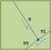
The image below shows the intersect between the shortest path shapefile and the polygon file for a single cell. In this example, routes from respectively 8 and 91 households converge onto one road (summed to 99 households) towards the waste management facility.

The intersected shapefile is then exported into Excel where the following calculations are performed:
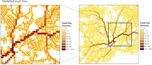
Figure 1: Modelled truck flows - example
Nr of hh Waste transported1 Truck flow2
Households Tonnes / y Trucks/y one direction Trucks/y two directions
8 11.6 1.5 2.9
91 132.3 16.5 33.1
99 143.9 18.0 36.0
1.Amount of waste transported is calculated as the number households multiplied by the average annual tonnes of waste produced per household (in this case 1.454 tonnes/year)
2. Truck flow is calculated as the waste transported divided by the average truck capacity (tonnes): in this case 8 tonnes/truck.

Figure 1 shows the modelled routes and the associated modelled truck flows
See also

Integrated Environmental Health Impact Assessment System
IEHIAS is a website developed by two large EU-funded projects Intarese and Heimtsa. The content from the original website was moved to Opasnet.
Topic Pages
Toolkit
Data

Boundaries · Population: age+sex 100m LAU2 Totals Age and gender · ExpoPlatform · Agriculture emissions · Climate · Soil: Degredation · Atlases: Geochemical Urban · SoDa · PVGIS · CORINE 2000 · Biomarkers: AP As BPA BFRs Cd Dioxins DBPs Fluorinated surfactants Pb Organochlorine insecticides OPs Parabens Phthalates PAHs PCBs · Health: Effects Statistics · CARE · IRTAD · Functions: Impact Exposure-response · Monetary values · Morbidity · Mortality: Database

Examples and case studies Defining question: Agriculture Waste Water · Defining stakeholders: Agriculture Waste Water · Engaging stakeholders: Water · Scenarios: Agriculture Crop CAP Crop allocation Energy crop · Scenario examples: Transport Waste SRES-population UVR and Cancer
Models and methods Ind. select · Mindmap · Diagr. tools · Scen. constr. · Focal sum · Land use · Visual. toolbox · SIENA: Simulator Data Description · Mass balance · Matrix · Princ. comp. · ADMS · CAR · CHIMERE · EcoSenseWeb · H2O Quality · EMF loss · Geomorf · UVR models · INDEX · RISK IAQ · CalTOX · PANGEA · dynamiCROP · IndusChemFate · Transport · PBPK Cd · PBTK dioxin · Exp. Response · Impact calc. · Aguila · Protocol elic. · Info value · DST metadata · E & H: Monitoring Frameworks · Integrated monitoring: Concepts Framework Methods Needs
Listings Health impacts of agricultural land use change · Health impacts of regulative policies on use of DBP in consumer products
Guidance System
The concept
Issue framing Formulating scenarios · Scenarios: Prescriptive Descriptive Predictive Probabilistic · Scoping · Building a conceptual model · Causal chain · Other frameworks · Selecting indicators
Design Learning · Accuracy · Complex exposures · Matching exposure and health · Info needs · Vulnerable groups · Values · Variation · Location · Resolution · Zone design · Timeframes · Justice · Screening · Estimation · Elicitation · Delphi · Extrapolation · Transferring results · Temporal extrapolation · Spatial extrapolation · Triangulation · Rapid modelling · Intake fraction · iF reading · Piloting · Example · Piloting data · Protocol development
Execution Causal chain · Contaminant sources · Disaggregation · Contaminant release · Transport and fate · Source attribution · Multimedia models · Exposure · Exposure modelling · Intake fraction · Exposure-to-intake · Internal dose · Exposure-response · Impact analysis · Monetisation · Monetary values · Uncertainty
Appraisal