Route modelling for IEHIAS: Difference between revisions

From Opasnet
Jump to navigation Jump to search
(Created page with "Category:IEHIAS :''The text on this page is taken from an equivalent page of the IEHIAS-project. File:routemodellingiehias.png|thumb|400px|Figure 1: Exa...")
 
No edit summary
 
Line 12: Line 12:


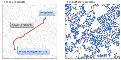
When running the script the user will be asked to define the network, origin and destination data.  The end result is a shapefile with shortest paths routes between every origin and destination locations along the road network (see Figure 1).
==See also==
{{IEHIAS}}

Latest revision as of 20:08, 25 September 2014

The text on this page is taken from an equivalent page of the IEHIAS-project.
Figure 1: Examples of routes modelled

The route model simulates routes between an origin (e.g. a household) and a destination (a waste management site). At its simplest, this can be done just by finding the shortest distance between the two. More realistically, the model can allow for differences in the cost of travelling along each route - for example, depending on traffic speed, road tolls or other barriers. Here, different cost weights were assigned to different road types.

Modelling is done in ArcGIS. An ArcView3.2 script, which can be downloaded from the ESRI website, is used to perform this analysis. The script needs the following geographical information in order to perform the route modelling:

  • Network data: digital road network
  • Origin data: postcodes (or other population centroids) with information of population or household numbers
  • Destination data: waste management sites (e.g. waste transfer stations, incinerators, landfill sites).

When running the script the user will be asked to define the network, origin and destination data. The end result is a shapefile with shortest paths routes between every origin and destination locations along the road network (see Figure 1).

See also

Integrated Environmental Health Impact Assessment System
IEHIAS is a website developed by two large EU-funded projects Intarese and Heimtsa. The content from the original website was moved to Opasnet.
Topic Pages
Toolkit
Data

Boundaries · Population: age+sex 100m LAU2 Totals Age and gender · ExpoPlatform · Agriculture emissions · Climate · Soil: Degredation · Atlases: Geochemical Urban · SoDa · PVGIS · CORINE 2000 · Biomarkers: AP As BPA BFRs Cd Dioxins DBPs Fluorinated surfactants Pb Organochlorine insecticides OPs Parabens Phthalates PAHs PCBs · Health: Effects Statistics · CARE · IRTAD · Functions: Impact Exposure-response · Monetary values · Morbidity · Mortality: Database

Examples and case studies Defining question: Agriculture Waste Water · Defining stakeholders: Agriculture Waste Water · Engaging stakeholders: Water · Scenarios: Agriculture Crop CAP Crop allocation Energy crop · Scenario examples: Transport Waste SRES-population UVR and Cancer
Models and methods Ind. select · Mindmap · Diagr. tools · Scen. constr. · Focal sum · Land use · Visual. toolbox · SIENA: Simulator Data Description · Mass balance · Matrix · Princ. comp. · ADMS · CAR · CHIMERE · EcoSenseWeb · H2O Quality · EMF loss · Geomorf · UVR models · INDEX · RISK IAQ · CalTOX · PANGEA · dynamiCROP · IndusChemFate · Transport · PBPK Cd · PBTK dioxin · Exp. Response · Impact calc. · Aguila · Protocol elic. · Info value · DST metadata · E & H: Monitoring Frameworks · Integrated monitoring: Concepts Framework Methods Needs
Listings Health impacts of agricultural land use change · Health impacts of regulative policies on use of DBP in consumer products
Guidance System
The concept
Issue framing Formulating scenarios · Scenarios: Prescriptive Descriptive Predictive Probabilistic · Scoping · Building a conceptual model · Causal chain · Other frameworks · Selecting indicators
Design Learning · Accuracy · Complex exposures · Matching exposure and health · Info needs · Vulnerable groups · Values · Variation · Location · Resolution · Zone design · Timeframes · Justice · Screening · Estimation · Elicitation · Delphi · Extrapolation · Transferring results · Temporal extrapolation · Spatial extrapolation · Triangulation · Rapid modelling · Intake fraction · iF reading · Piloting · Example · Piloting data · Protocol development
Execution Causal chain · Contaminant sources · Disaggregation · Contaminant release · Transport and fate · Source attribution · Multimedia models · Exposure · Exposure modelling · Intake fraction · Exposure-to-intake · Internal dose · Exposure-response · Impact analysis · Monetisation · Monetary values · Uncertainty
Appraisal