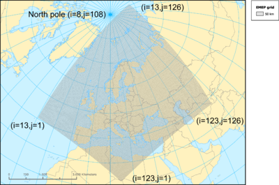
EMEP grid
Jump to navigation
Jump to search
This page is a encyclopedia article.
The page identifier is Op_en4587 |
|---|
| Moderator:Jouni (see all) |
|
|
| Upload data
|
EMEP grid is a grid widely used in Europe for georeferenced data. Typically, the grid has 50 km * 50 km cells (sometimes 150 km * 150 km).

EMEP 50 coordinate system definition (for ArcGIS):
PROJCS["EMEP_50_Kilometer_Grid",
GEOGCS["GCS_Sphere_EMEP",
- DATUM["D_Sphere_EMEP",SPHEROID["Sphere_EMEP",6370000.0,0.0]],
- PRIMEM["Greenwich",0.0],
- UNIT["Degree",0.0174532925199433]],
PROJECTION["Stereographic_North_Pole"],
PARAMETER["False_Easting",8.0],
PARAMETER["False_Northing",110.0],
PARAMETER["Central_Meridian",-32.0],
PARAMETER["Standard_Parallel_1",60.0],
UNIT["50_Kilometers",50000.0]]
See also
- How to convert from/to EMEP grid to/from longitude and latitude.
- EMEP grid homepage.
- EMEP grid maps at EEA.