The impacts of the CAP

From Opasnet
Jump to: navigation, search
The text on this page is taken from an equivalent page of the IEHIAS-project.
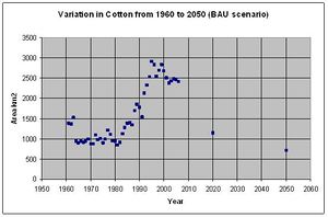
Figure 1. Variation of area cultivated with cotton between 1960 and 2006 and projections to year 2020 and 2050 for the Business As Usual (BAU) scenario in Thessaly and Central Macedonia.
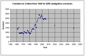
Figure 2. Variations of area cultivated with cotton between 1960 and 2006, and projections to year 2020 and 2050, for the mitigation scenario in Thessaly and Central Macedonia.

According to the ATEAM scenarios, there is a significant reduction in future arable land in the regions of study (Thessaly and Central Macedonia). The area of arable land is anticipated to fall from 9547 km2 (baseline) to 7096 km2 (under the BAU scenario) and 8025 km2 (under the mitigation scenario) in 2020; by 2050, the area would further decline tyo 5610 km2 and 7448 km2, respectively.

The most significant decrease in arable land occurs for the BAU scenario in 2050, where the available arable land is reduced by about one half. In the Greek case study, cotton cultivation currently accounts for the majority of arable land: as Figure 1 (below) shows, the area of cotton was relatively stable from 1960 to 1980, but the subsidies available after Greece had joined the EU encouraged a tripling of the area under cotton, to ca. 2800 km2 by the year 2000. Under the present CAP policies, whereby subsidies will be eliminated, a significant reduction in cotton cultivation is anticipated. In recognition of this, and expected water scarcity, the BAU therefore foresees that the cultivated area will fall back to its historic levels (Figure 1). It is also expected that other crops will be expanded to fill the land released, especially cereal and maize - the latter also considered an energy crop: cereals are projected to expand by 45% and maize by 30%.

Under the mitigation scenarios, the reduction in cotton cultivation is not expected to be so marked, largely because water shortages will be less severe due to the smaller rise in global temperatures. As Figure 2 shows, cultivation of cotton is thus assumed to decline to about 1500 km2 by 2050 - i.e. greater that the historic average of 1950 to 1980, but significantly smaller than the maximum seen around the year 2000.

As for the BAU, the areas of cereals and maize are anticipated to increase (by 35% and 25% respectively).
See also

Integrated Environmental Health Impact Assessment System
IEHIAS is a website developed by two large EU-funded projects Intarese and Heimtsa. The content from the original website was moved to Opasnet.
Topic Pages
Toolkit
Data

Boundaries · Population: age+sex 100m LAU2 Totals Age and gender · ExpoPlatform · Agriculture emissions · Climate · Soil: Degredation · Atlases: Geochemical Urban · SoDa · PVGIS · CORINE 2000 · Biomarkers: AP As BPA BFRs Cd Dioxins DBPs Fluorinated surfactants Pb Organochlorine insecticides OPs Parabens Phthalates PAHs PCBs · Health: Effects Statistics · CARE · IRTAD · Functions: Impact Exposure-response · Monetary values · Morbidity · Mortality: Database

Examples and case studies Defining question: Agriculture Waste Water · Defining stakeholders: Agriculture Waste Water · Engaging stakeholders: Water · Scenarios: Agriculture Crop CAP Crop allocation Energy crop · Scenario examples: Transport Waste SRES-population UVR and Cancer
Models and methods Ind. select · Mindmap · Diagr. tools · Scen. constr. · Focal sum · Land use · Visual. toolbox · SIENA: Simulator Data Description · Mass balance · Matrix · Princ. comp. · ADMS · CAR · CHIMERE · EcoSenseWeb · H2O Quality · EMF loss · Geomorf · UVR models · INDEX · RISK IAQ · CalTOX · PANGEA · dynamiCROP · IndusChemFate · Transport · PBPK Cd · PBTK dioxin · Exp. Response · Impact calc. · Aguila · Protocol elic. · Info value · DST metadata · E & H: Monitoring Frameworks · Integrated monitoring: Concepts Framework Methods Needs
Listings Health impacts of agricultural land use change · Health impacts of regulative policies on use of DBP in consumer products
Guidance System
The concept
Issue framing Formulating scenarios · Scenarios: Prescriptive Descriptive Predictive Probabilistic · Scoping · Building a conceptual model · Causal chain · Other frameworks · Selecting indicators
Design Learning · Accuracy · Complex exposures · Matching exposure and health · Info needs · Vulnerable groups · Values · Variation · Location · Resolution · Zone design · Timeframes · Justice · Screening · Estimation · Elicitation · Delphi · Extrapolation · Transferring results · Temporal extrapolation · Spatial extrapolation · Triangulation · Rapid modelling · Intake fraction · iF reading · Piloting · Example · Piloting data · Protocol development
Execution Causal chain · Contaminant sources · Disaggregation · Contaminant release · Transport and fate · Source attribution · Multimedia models · Exposure · Exposure modelling · Intake fraction · Exposure-to-intake · Internal dose · Exposure-response · Impact analysis · Monetisation · Monetary values · Uncertainty
Appraisal